The first rays of bright, golden sunlight stream through the blinds about the same time that the daily wind picks up. Our neighbors chirp happily, as they fly through the air, because of the abundance of mosquitos. At first light, dozens of cliff swallows began their swoop and scoop show at the Malheur Field Station.
The sun grows ever more intense, bathing our home away from home in a wash of light as it sits in the middle of a rocky, weedy field. Yes, this is where you really get away from it all, or at least all that’s commonplace to a suburbanite. But you give up something and you get something back. In this case, the dividend is those mosquitos--swarms of them. Every trip between truck and trailer is a dash to minimize mosquitos bites, then a hunting expedition to swat all those that came in with you.
But today, we plan to rise above the swarms, literally. Our destination, the Steens Mountain Loop Road, goes close to the summit of Steens Mountain at 9733 feet. Or at least the road goes there--whether we can is another story. As it is only early June, snow likely covers the road. We have a Plan B, which is to drive as far as we can, then hike the rest of the way to the Kiger Gorge.
During the forty mile drive to Frenchglen, we feel the webs in our western Oregon feet crack and fade away as the dryness of the area takes hold. We acclimatize once again to the strange terrain of sagebrush surrounding marsh land and recall the birds that had become familiar on our last trip: the white faced ibises that look like cormorants in flight, the yellow headed blackbirds with their strangled song, the black terns that look more sooty than black. In our two year absence, little has changed.
In “downtown” Frenchglen, we turn off the highway onto the gravel Loop Road and look east as the Steens completely fills our view. After a few miles, we come to the junction at Page Springs where a sign gives us the not-unexpected news: “Road Condition: Closed at Gate 2.” Looks like we go with Plan B.
The road starts to slope upward and as now-experienced gravel road drivers, we speed up to 35 miles an hour so that we can’t feel the washboards. As we climb, we begin to see evergreens and one lonely pronghorn antelope. For a road that we have driven only once before (okay twice, once up and once down) things look surprisingly familiar.
We bypass Lily Lake, where we ate lunch two years ago beside the skeleton of a deer, and then the Fish Lake Campground turnoff. Sure enough, not far past Fish Lake, the big yellow gate just before Jackman Park ends our vehicle trip. We scramble out of the truck and prepare for the hike.
Just around the corner where we leave the truck we look across and down into the small aspen grove that is the Jackman Park campground. Here it is June and the place is totally deserted. Of course we are at 8,000 feet and everything would have to be packed in because of the gate, but hey, where are all the hardy campers?
After rounding the hollow of Jackman Park, we begin climbing. We discover this is a breathless task at this elevation. But onward and upward, then a slight downward, to another small grove of deciduous trees and a sign telling about the Basque shepherds who used to work the mountain. Just past the sign, we come across our first expanse of snow that completely covers the road. We skirt the edge of the snow, drawing near a bubbly creek that has formed from the snow melt. We continue climbing and are surprised to see a family of three overtaking us. (They were probably from Colorado and used to the elevation.) They have the same goal--to reach the Kiger Gorge. Brief pleasantries and they march on ahead of us.
The expansive view on one side contrasts with the looming mountain on the other. Patches of snow cling here and there on the dark rock face of the mountain, while the vegetation is still spring green. We skirt the Little Blitzen Gorge. We encounter a few more snowy areas, some of which we are forced to walk through, having to pause thereafter because of snowblindness. I catch some movement up on the ridge as high as we can see, where three pronghorn antelope pause to look at us before bounding over the top of the ridge.
After walking for a few hours, Cal starts to feel light-headed, presumably the effects of the altitude. We stop for lunch, sitting on some rocks to rest and watch some horned larks. We decide to continue, but soon Cal is feeling poorly again, especially when we come to another hill where snow covers the road.
We discuss whether to turn back, but Cal decides he will wait for me while I climb the ridge to see if I can get an idea of how close we are to our goal. I slush through the snow to a dry spot off the road and climb up. Upon reaching the top of the ridge, I can see the road continuing on and scan ahead with my binoculars. Wait! There’s a sign! I can’t quite make it out. I try to yell down to Cal, but the distance and the breeze must deaden the sound because he doesn’t even look up.
The ridge drops away and I have to return to the slushy road to continue on. As I try to get back to the road, my feet sink in knee deep for a few steps, but then I reach the road where the snow is packed and not so deep. I walk another hundred yards to be sure, but yes, the sign says “Kiger Gorge, 1/4 mile.” I trot back down the road until I reach the snow, then carefully pick my way down the hill. Good sport that he is, Cal agrees to continue on. Just as we crest the hill, we see our fellow hikers making their way back toward us.
When we meet again, they encourage us to continue. One more minor hill, then we reach the turnoff to the gorge. Just as we are about to turn down, we hear a huge rumble. We look in the direction of the noise just in time to see a military-grey fighter jet appear over summit of the mountain and then plunge over the sheer east side. A few seconds later, another jet follows.
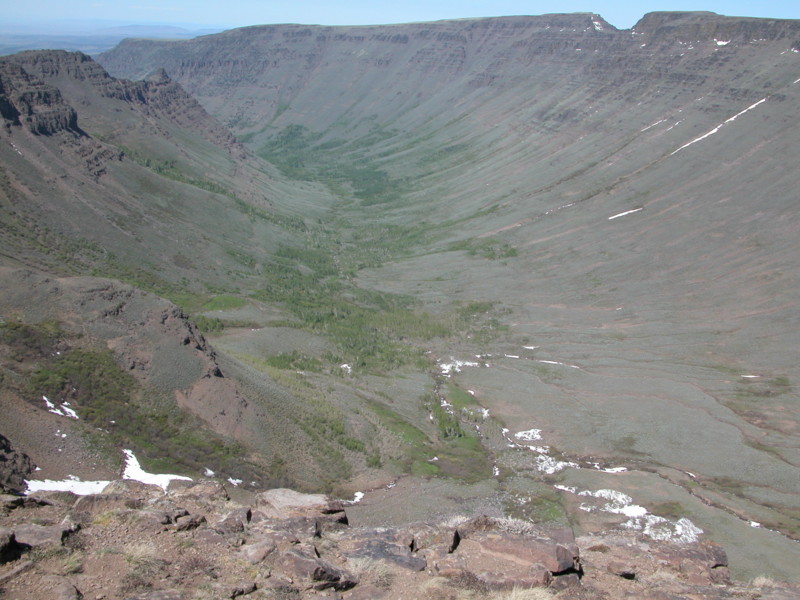
Our path levels off and even starts downhill where we reach a small gravel parking area. As we approach, we get a preview of what is to come, but then we reach the edge of the gorge. Hundreds of feet below, a small stream churns and drops, surrounded by aspens and cupped in a green U-shaped valley. The other side of the gorge looms even higher than where we stand. Giant banks of snow are corniced at the top of the gorge, seeming to defy gravity. Small streams drizzle past our feet and disappear under the snow banks, presumably forming tremendous waterfalls over the edge of the cliff where we can’t see. We hold tight to our hats; the wind here could carry them away, never to be seen again.
Distance stops being the next-door neighbor’s house or the next stoplight. Distance is hundreds of feet down and miles outward. Distance becomes only the limitation of our vision. And yet, there is more. We plot our next trip–sometime later in the summer when we can drive the road and zoom over the miles that we trudged. Next time, we go to the summit!
