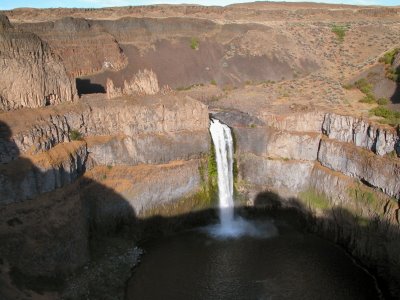
Like discovering a shiny jewel in a pile of rocks, the 198-foot Palouse Falls surprises not only in its beauty but also in location. Among brown and gold rolling hills in the southeastern Washington desert, the water edge and canyon walls display thriving green.
The powerful falls you see are but a trickle compared to the giant floods scientists believe roared through here some 15,000 years ago. Ice age glaciers dammed the Clark Fork River in Montana, forming glacial Lake Missoula. At its peak, the lake may have been 2,000 feet deep (about the depth of Crater Lake) and spanned 3,000 square miles. The breach of the colossal ice dam sent a wall of water pouring through southeast Washington, scouring all the top soil and ripping deep channels in the volcanic basalt. The flood water roared through the Columbia Gorge and leaked into the Willamette Valley. This was not a one-time event, according to scientists, but occurred repeatedly as the dam formed and breached–-as many as 90 times.
As you gaze down at the chasm into which the falls plunge, you realize that there is simply not enough water there to make a hole that big. The scientific explanation makes some sense–even to the casual observer–but is not without controversy. Apparently, many geologists have a basic aversion to catastrophic events, believing instead that geological change result from slow and steady processes.
Ponder the controversy as you explore the area in several directions. One trail goes down the side of the cliff to the splash pool at the bottom of the falls, where we saw several young men fishing. Another trail leads to an Eden-like area of gentle cataracts surrounded by vegetation. Continuing on from this area takes you to the very top of the falls and the stone “castle.”
In the heat of summer, the grounds at the state park are an oasis of green and trees to which birds and other wildlife gather. Camping is permitted in the state park and we backed our trailer up to the grass, spending quiet nights all alone there in July. In the morning, the squeaky chatter of the western kingbirds and Bullocks orioles acted as an alarm clock. During summer days you will also likely see swallows, swifts and wildflowers. If you don’t want to camp, you might enjoy a picnic here on the grass to fortify you for a hike.
To get there, head toward the Tri-Cities. From Highway 395, go east on State Route 26 twenty two miles to Washtucna. Turn south on SR 261 fifteen miles to the turnoff for the state park. If you are as fascinated as we were with the whole idea of the Ice Age Floods, take a look at the information on the Ice Age Institute’s website.
No comments:
Post a Comment