Friday, July 17, 2015

In My Own Backyard

One of these pictures was shot on the Big Island of Hawaii, one was taken at the Trail of Two Forests south of Mount St Helens, in Washington.  Can you tell which is which?


Here's an explanation of what you are seeing in these photos:

Hot lava flows around a standing tree, which erupts in flames, but cools the lava sufficiently for it to harden.  The tree burns away leaving a hole. 

Cooled lava like this is called basalt. The landscape of Hawaii, currently growing from the eruption of Kilauea, is just a fresher version of similar rock in the Pacific Northwest. There is a lot of basalt in the Hawaiian Islands, but we have a lot of basalt here, too!  Much of ours came from huge vents in what is now eastern Oregon and Washington. That lava flowed east into Idaho and west all the way to the ocean.

The lava around Mount St Helens came from, yes, eruptions of Mount St Helens.  The other thing that Mount St Helens spews out is ash, and there is a lot of that too.


Where slides have occurred near Kalama Creek, it is easy to see that there is a whole lot of ash under the duff of the forest floor.

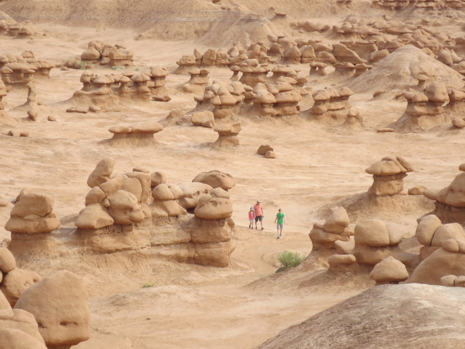
At one new section of the trail, we came across these little ash towers.  Each tower has a little rock or pebble on top, protecting the ash directly underneath from erosion.  This is a similar phenomenon to the creation of  the "goblins" of Goblin Valley and many other formations in southern Utah: a erosion-resistant cap on top of a less-resistant base underneath.

Going back to our lava flows above, what happens if the tree in the way of the lava is not standing? Well, you might get something like this:
A tunnel where the downed tree once was.  At the Trail of Two Forests, it is possible to descend a short ladder and crawl through this tunnel, which must have formed from two downed trees that were immersed in lava.  The tunnel is open at each end, but crawling through requires a sharp turn (and knee pads if you are as old as me.)

Oh yes, and the top picture above was taken in Volcanoes National Park on the Big Island of Hawaii.

Monday, May 26, 2014

To the Dry Side

Life west of the Cascade Mountains is moss (it grows everywhere!), moisture and moderation: it rarely gets really hot or cold. Crossing to the east side of those mountains changes vegetation, climate and the view; the very air feels different. We like to visit those arid places, but I'm always happy to return to the velvet of the west.

Returning this blog to our travels of last summer, we now leave the verdant side behind, watching Mount Rainier settle into the horizon as we head east.  We made a brief stop at Ginkgo Petrified Forest State Park, near Vantage, Washington to acclimatize to our new environment.

 Perched above the Columbia River, we find this park rocks!

Petrified:


and art:

Because this was a brief stopover and because the air was oppressive, we didn't take the hiking trail to see more examples of petrified wood.  Another time.

Wednesday, December 25, 2013

Merry Christmas!

We went for walk in the Tualatin Hills Nature Park today.
 Some kind person had walked through the park leaving treats for the wildlife!
 What a great idea!
 Making life a little easier for the critters one day out of the year.

Thursday, November 14, 2013

Little Sun at Sunrise - East Side of Mount Rainier

Perched on the northeast side of Mt Rainier at White River Campground, we had easy access to the beautiful Sunrise area, where the wildflowers and birds gave us a good excuse to take it slow.  (The fact that we started out at over 6000 feet and went up from there had nothing to do with it. . .)
Our goal was Dege Peak, elevation 7,006 feet.  Cal was "happy" to get to the top, where he could take a break.

Because of the overcast sky, we did not get all the promised view: "Look for Rainier, of course, but also the Sarvent Glaciers below the Cowlitz Chimneys, due south; the White River drainage and Highway 410, to the east; Sunrise and Clover Lakes of the Palisades chain directly below to the northeast; and the Stuart Range, Glacier Peak, and Mount Baker far off to the north.  If it's very clear, you can even see the Olympic Mountains from here." (from Day Hike! Mount Rainier)  Nope.

On the plus side, we got to watch a thunderstorm roll in.


And we had a visitor who might have been looking for a handout:


Thursday, September 26, 2013

Moving Day and A Solo Hike

We moved from the southwest corner of Mount Rainier to northeast: White River Campground.  We wanted to arrive early because we had no reservations.  It took us a few attempts to find a spot we liked, but there seemed to be several available.  Could it have anything to do with this sign?

Well, I'm sure I'll sleep better tonight.

This old patrol cabin is in the campground, a left-over ranger station by the Wonderland Trail, the trail that circles the mountain.

I walked by the cabin on my way to the: 
Cal was not feeling up to a hike, but I wanted to do a little exploration.  I decided to take the short trail to Emmons Moraine.  The trail parallels the White River, with several great views of Little Tahoma Peak.
Little Tahoma on the left of Rainier and the glacial moraine in the foreground
The trail up the side of the moraine was sandy and slippery, but I had talked to an elderly couple who had just come from there. If they could do it, a young'un like me could!

Scenes from the top of the moraine:
Don't know if this lake has a name
Another disappointingly dirty glacier
Emmons Glacier has the largest surface area of any glacier in the contiguous United States (according to Wikipedia)
Guess it's time to turn around.

Back at the campground, I saw this great bumper sticker.  Even though I saw it when most of the day was over, I thought it was a good summary of the day.


Tuesday, September 24, 2013

Paradise on Mount Rainier and Trees To Look Up To

What does Paradise look like?  Seen from the Nisqually Vista Trail, it looks like this:
Lupine
Avalanche lilies

Such a beautiful place, even the wildlife is having  fun!

The Nisqually Glacier itself was a bit of a scenic disappointment.
It's hard to tell which is mountain and which is glacier, except for the Nisqually Trickle flowing from the glacier.

And hard to believe this is the beginning of the robust river that pours into the Puget Sound at the Nisqually National Wildlife Refuge just over 80 miles away.

From Paradise, there's also a picture perfect view of the Tatoosh Mountains.


We also toured the Grove of the Patriarchs.  Passage to the Grove is over this fun suspension bridge.


Yep, the "Patriarchs" are big trees (random child posed for perspective).

Thursday, September 19, 2013

The Big Trip - Day 1, Mount Rainier National Park

What is the difference between fantasy and a great road trip? With the trip, you come back with pictures!

Saturday the 27th of July saw us on the road to Mount Rainier National Park. Set up in the Cougar Rock Campground still left us time for a short hike.
Mount Rainier frosted and fluffy
The trailhead for Carter Falls is almost directly across the highway.  We followed the description in an earlier version of Day Hike! Mount Rainier, but here is another description.
Look for the sign!
Down the slope to the boulder field, we had our first glacier lesson, although I didn't know it at the time. I thought, "There must be a lot of spring flooding to clear out this river bed so much."  We were to learn later that this rocky mess is not the result of spring flooding, but a remnant of the Nisqually Glacier.  We are hiking over the old glacier bed.

Next, we cross a footbridge over the rushing chocolate milk of the Nisqually River.
Cal crossing the Nisqually River and of course, stopping for a photo
Our first mammal sighting
Carter Falls

A great first day: geology, wildlife, wildflowers, beautiful sights and the glow of satisfaction as we settled into our camp chairs that evening.